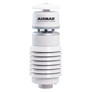
150WXRS NMEA 0183 / 2000® WeatherStation® - SolarShield and Rain Sensor - RS422
Part #WS-150WXRS-RS422
MFG #150WXRS-RS422-100321

Rain Sensor with Solar-radiation Shield
Airmar’s WeatherStation WXRS provides real-time information on rain intensity, accumulation, and event duration. An acoustic sensor measures the impact energy of individual raindrops on the “umbrella” located on the top of the instrument. This patented rain-detecting sensor is virtually maintenance free. It has no moving parts or components that need to be emptied, cleaned, or will become clogged by debris.
With minimal maintenance, the unique rain sensor plus a full suite of ultrasonic wind, temperature, barometric pressure, and relative humidity sensors, the WeatherStation 150WXRS delivers a significantly lower total cost of ownership than traditional measurement devices.
- Ultrasonic measurement of apparent wind speed and direction
- Acoustic measurement of rain accumulation, intensity, and duration
- Internal compass for wind-speed data referenced to magnetic north
- GPS for time stamping correcting for the variation between magnetic and true north
- Maintenance-free operation is superior to tipping buckets, weighing gauges, optical measurement. No obstruction and data integrity loss due to debris.
- Rugged, compact, UV stabilized housing with no moving parts
- Brand: Airmar TechnologyAir Temp Accuracy: ±0.3°C at 20°CAir Temp Range: -40 to 80°C (-40 to 176°F)Air Temp Resolution: 0.1°CBarometric Pressure Accuracy: ±0.5 hPa at 25°C (or better)Barometric Pressure Range: 300 to 1100 hPaBarometric Pressure Resolution: 0.1 hPaCerts And Standards: CE, IPX6, RoHS, IEC61000-4-2, IEC60945, IEC60950_1C, IEC60950_22A, EN55022, EN55024, EN14982Comm Method: NMEA 2000®Communications Available Hardware Interface: Serial RS232, Serial RS422Communications Available Protocol: Serial - NMEA 0183Communications Serial Data Transmission Code: ASCIICommunications Serial Output Rate: 1 Hz typical. User selectable. 10 Hz maximum recommendedCountry of Origin: USADisplay Connector: Cable RequiredExterior Color: WhiteExterior Color: WhiteGPS Position Accuracy: 3 m (10') CEPMounting Thread: Standard 1”-14 UNS (3/4” NPT optional)NMEA 2000 LEN: 3Note: Cables sold separately unless otherwise specifiedOperating Temp Range: -25 to 55°C (-13 to 131°F)Pitch Roll Accuracy: ±1° in range of ±30°Pitch Roll Measurement Type: MEMSPitch Roll Range: 50°Power Supply Current: <105 mA (<1.25 W) at 12 VDCPower Supply Voltage: 9 to 40 VDCRainfall Amount: Cumulative accumulation after the latest automatic or manual resetRainfall Amount Accuracy: 5% TypicalRainfall Amount Output Resolution: 0.01 mmRainfall Duration: Counting each second whenever water droplet is detectedRainfall Duration Output Resolution: 1 secondRainfall Intensity: One minute running average in 10 second intervalsRainfall Intensity Output Resolution: 0.1 mm/hRainfall Intensity Range: 0 to 200 mm/hRecommended Use: Land-Based StationaryRefurbished: NoRH Accuracy: ±3% RH at 0 to 90% RH at 20°CRH Range: 0 to 100% RHRH Resolution: 0.1% RHRoHS Compliant: YesSensor Connector: 10WSThree Axis Compass Dynamic Heading Accuracy: 2° dynamic heading accuracyThree Axis Compass Range: 0 to 359.9°Three Axis Compass Static Heading Accuracy: 1° static heading accuracyWeight: 350 g (0.8 lb.)Wind Direction Accuracy: ±3° at 10 m/sWind Direction Range: 0° to 359.9°Wind Direction Resolution: 0.1°Wind Speed Accuracy: 5% at 10 m/s at 4 anglesWind Speed Calculations: User configurable dampingWind Speed Range: 0 to 40 m/s (0 to 89 MPH)Wind Speed Resolution: 0.1 m/sHumidity: Optional, IncludedWaterproof Rating: IPX6
Serial Data Output Protocol
NMEA 0183 Sentence Structure – Comma Delimited ASCII Format $GPGGA GPS Fix Data $HCHDG Heading, Deviation, and Variation $WIMDA Meteorological Composite $WIMWR Relative Wind Direction and Speed $YXXDRA Wind Chill, Heat Index $YXXDRB Pitch and Roll $WIXDR Rain Measurements $GPDTM GPS Datum Reference $GPGLL Geographic Position—Latitude and Longitude $GPGSA GNSS DOP and Active Satellite $GPGSV Satellites in View $GPRMC Recommended Minimum GNSS $GPVTG COG and SOG $GPZDA Time and Date $HCHDT True Heading $HCTHS True Heading and Status $WIMWD Dynamic True Wind Speed and Direction $WIMWVT Dynamic True Wind Speed and Direction 


